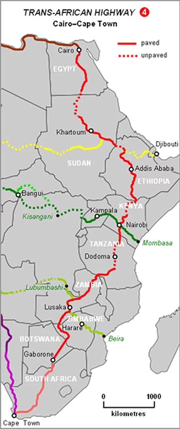
AFRICA’S longest road, the Cairo-Cape Town Highway, spans a remarkable 6,000 miles, stretching from the Mediterranean coast of Egypt to South Africa’s southernmost tip. Officially known as Trans-African Highway 4, this monumental route is a part of a transcontinental road network being developed by the United Nations Economic Commission for Africa (UNECA), the African Development Bank (AfDB), and the African Union.
Designed to promote trade, unity, and reduce poverty across the continent, the Cairo-Cape Town Highway weaves through 10 countries—Egypt, Sudan, South Sudan, Ethiopia, Kenya, Tanzania, Zambia, Zimbabwe, Botswana, and South Africa. The highway’s purpose reaches far beyond mere connectivity; it embodies Africa’s commitment to strengthening regional trade, enabling efficient movement of goods, and fostering stronger economic ties among these nations.
A vision born in history, revived for the future
The concept of a road spanning the African continent dates back to the British Empire’s proposed ‘Cape to Cairo Red Line,’ a road intended to connect British colonies from north to south. Although initially named the Cape to Cairo Road, and later the Pan-African Highway, the ambitious project was abandoned with the end of colonial rule.
It wasn’t until the 1980s that the idea was revived under the Trans-African Highway initiative, a project aimed at enhancing regional connectivity through an intricate network of highways. This modern route largely traces the original path envisioned, with some deviations to accommodate current road systems and geographical challenges. The highway begins in Alexandria on Egypt’s Mediterranean coast, passing through Cairo and then down the continent to Cape Town, South Africa.
Economic and social impact
The Cairo-Cape Town Highway is a vital part of Africa’s strategy to boost trade and ease travel across national borders. By connecting these 10 nations, it provides a streamlined route for transporting goods, creating more economic opportunities, and reducing the continent’s reliance on external trade routes. Infrastructure development along this route also supports local businesses and improves access to essential services in remote areas.
For landlocked countries like Zambia and Zimbabwe, the highway offers direct access to port cities, crucial for their export-driven economies. The increased ease of transporting goods will enhance trade competitiveness, support local economies, and allow faster delivery of products, such as agricultural produce, to international markets.
Bridging regions, strengthening unity
The Cairo-Cape Town Highway represents more than just an infrastructure achievement; it is a symbol of Africa’s aspiration for interconnectedness and self-sufficiency. It brings Africa’s diverse regions closer together, fostering mutual economic dependency and shared development goals. According to the African Union, the highway is expected to contribute significantly to poverty alleviation by facilitating trade and reducing transportation costs.
With its completion, Africa’s longest road stands as a testament to the continent’s vision for unity and growth. It is a critical step toward establishing an African single market, enhancing the free flow of goods, people, and ideas across borders. As Africa continues to modernise its infrastructure, the Cairo-Cape Town Highway remains a bold reminder of the continent’s potential to drive its development and shape its future.


